
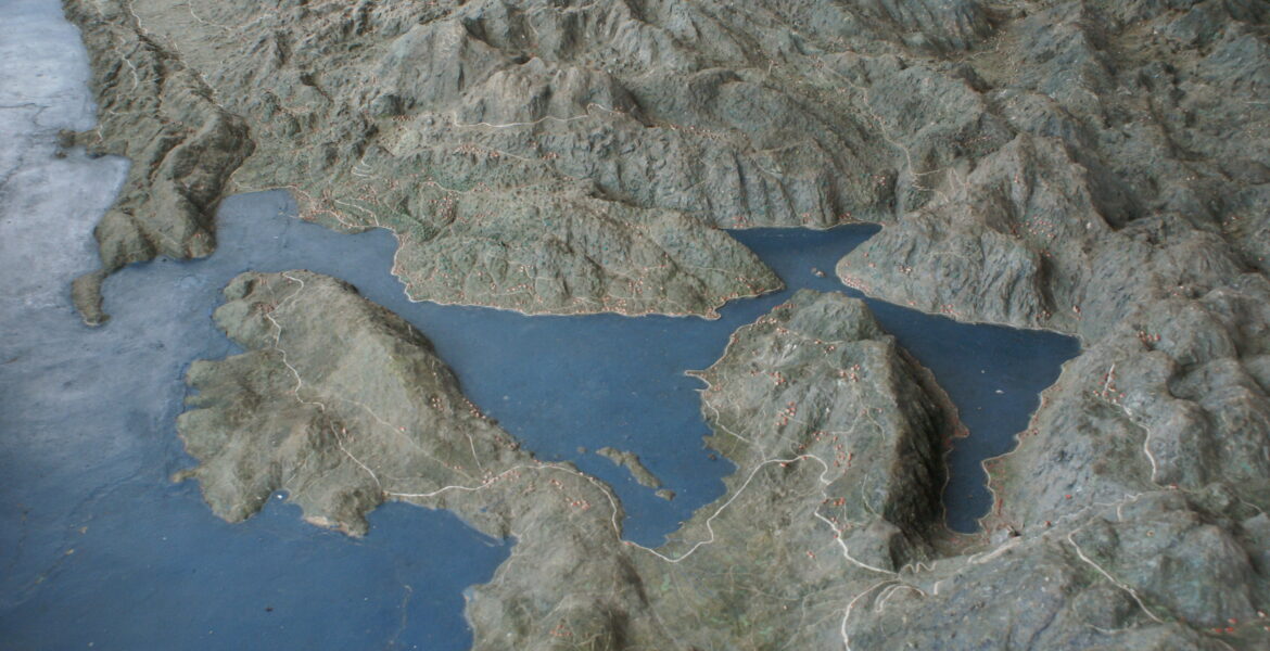
In Cetinje, the former capital of Montenegro, lies a fascinating relic from the Habsburg era: a relief map depicting Montenegro in remarkable detail across an area of 282 square metres. Unique in both its scale and form, it is unlike anything else of its kind. Diplomatic SOCIETY spoke with historian Mihailo Popović, who has researched the map and its origins.
The Habsburg map is known to very few people in Austria. How and when did you first come across it?
While researching medieval road networks in the Balkans, I came across an article from 1984 in the journal of the Military Geographical Institute in Belgrade dealing with relief maps in the former Yugoslavia. The Habsburg map was also mentioned in the article. I began researching it further and found a number of photographs of it online. At the time, there was relatively little information about the map in Montenegro, at least in the media. Interest only really began to grow when we started researching it ourselves.
What does researching a map like this actually involve? What happened after your initial online research?
Using ANNO, the Austrian National Library’s digital newspaper archive, I searched for keywords such as “Biljarda” – the former residence of the Prince-Bishop, next to which the map is located – and “relief map”. I was able to find a considerable amount of information in Austro-Hungarian newspapers from the wartime period.
For example, the Cetinjer Zeitung, which was published by the Austro-Hungarian Military General Government in Montenegro, reported on the map, which was quite a sensation at the time. These references eventually enabled me to establish an approximate period in which it was created. Work actually began shortly after the Habsburg conquest in January 1916 and continued until 1917.
In early March 2020 – shortly before the lockdown – I travelled to Cetinje with a project team for the first time to examine the map. We were just able to complete the first stage of the project and, based on photographs, create a 3D model of the relief map.
The map is unique in its form. What materials were used and how was it made?
The map was constructed from concrete. Metal rods of different lengths were attached according to scale to indicate elevations. The landscape was then presumably shaped by hand. Most likely, military maps were used as a reference, with the rivers and mountains possibly sketched out in pencil beforehand. Monasteries and churches, alpine pastures and meadows, the railway connections that existed at the time and many other details were also marked. Larger settlements were represented using houses made of concrete or plaster.
Originally, there was a bridge in the centre of the map which provided a more comprehensive view of it. Even at that time, the map was covered by a pavilion to protect it from the elements. However, the pavilion was destroyed in an earthquake in 1979 and replaced by a new structure a year later. Unfortunately, the bridge no longer exists, and the inscriptions have also disappeared.
We have also not yet been able to conclusively identify the names of the artists, although two names have been suggested. In any case, this relief map is absolutely unique, and I know of nothing comparable.
Why was such an elaborate map of Montenegro commissioned in the first place?
That is difficult to answer – I still ask myself that question today. It may, of course, have had operational or military purposes, but the front was actually located in what is now central and southern Albania, so Montenegro was not directly a theatre of war.
Another possibility is that the map was produced in connection with the exploration or development of raw materials.
There are around 100 boxes of military archival material in the War Archives in Vienna, more or less systematically organised, but so far I have not found anything conclusive on this particular question.
What other links existed between the Habsburgs and Montenegro? What visible remnants of the period of Habsburg occupation can still be found in the country today?
The cultural influence of Vienna certainly played an important role in Montenegro. Prince-Bishop Petar II, for example, regularly visited Vienna during the first half of the 19th century. At the time, Vienna was not only the centre of the monarchy, but also an important centre of Slavic culture. There was a lively literary exchange, and linguistic reforms also had their beginnings in Vienna.
As for the remnants of the Austro-Hungarian Monarchy in Montenegro, the infrastructure is certainly worth mentioning. Today, this is a rather complex subject, and research in Austria has evolved over time. In the past, the fortifications built by the Austro-Hungarian Monarchy would have been studied exclusively from a military-historical perspective. Today, they are viewed as part of an occupation. The most appropriate approach probably lies somewhere between these two perspectives.
In any case, the fortifications built by the Habsburgs at the time are extremely impressive. Some of them are located along the border with Bosnia and Herzegovina and were constructed between the 1860s and the First World War. Today, they stand abandoned amid the landscape. It is only when you visit them in person that you truly appreciate the scale of these installations.
There are also countless fortifications around the Bay of Kotor. When entering the bay today, you can still see the gun batteries. The fortifications are remarkably well preserved and look as though they were built only yesterday.
A fort was also constructed on Mamula Island, off the Bay of Kotor, occupying almost the entire island. It is important to emphasise once again that these structures were, of course, military infrastructure – neither peaceful nor beautiful in their original purpose – but from today’s perspective they are historically valuable.
The archival material also makes clear that, for military purposes, roads and bridges, water reservoirs and other water-supply infrastructure were constructed. On the one hand, the Austro-Hungarian Military General Government employed Montenegrin workers for these projects, who were actually paid. On the other hand, forced labour was also used, often involving prisoners of war from the Russian Empire.
This once again highlights the ambivalence of the military occupation. In general, these “remnants” need to be viewed critically, because they originate from a period of occupation.